Say goodbye to warm spring temps: chilly storm, rain headed for SoCal
Fast Break
Grace Toohey April 4, 2024
A cold, Pacific storm moving toward Southern California on Thursday is expected to bring rain, snow and winter-like temperatures that might break local records.
Here’s what you need to know about the system set to upend springtime weather for at least the next two days:
When is it coming?
The storm is expected to make its way inland and move south over California beginning Thursday. It arrived from the northern Pacific and brought frigid temperatures along with it.
Its just off the Northern California coast,” Mike Wofford, a National Weather Service meteorologist in Oxnard, said early Thursday. “The cold front is going to be moving through the area, probably for [Los Angeles], this evening and then overnight.”
Already the storm has started to have an impact, with rain and some low-elevation snow recorded in the Bay Area on Thursday morning, where temperatures dropped considerably from Wednesday’s highs.
Friday is expected to be even colder than Thursday, Wofford said.
Where can you expect to see storm effects?
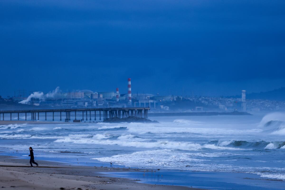
Pretty much all of California can expect to have some cold, wet weather from this storm from snow in the mountains to dangerous surf along the coast.
Showers and thunderstorms are forecast across the state through Friday and are expected to be intermittent and only severe in isolated areas.
In the Los Angeles County mountains and the Antelope Valley foothills including the Interstate 5 and Interstate 14 corridors a winter weather advisory will go into effect at 5 p.m. Thursday until late Friday, with officials warning that snow could make travel very difficult.
“Delays or temporary closures are possible over many mountain roads, including Interstate 5 over the Grapevine,” the National Weather Service said.
In the San Bernardino and Riverside County mountains, a winter storm warning will begin at 4 p.m. Thursday and last through late Friday. Officials warn that the heaviest snow is expected Friday, when driving through the mountains will be challenging, especially across the Cajon Pass.
“The hazardous conditions could impact the morning or evening commute,” the warning said. “Very strong winds could cause extensive tree damage.”
‘Unseasonably cold’: April storm bringing winter temperatures, low snow levels to California
Snow is expected Thursday and Friday across the Sierra Nevada, with the southern portion and some Kern County mountains under a winter weather advisory through Friday evening. There could be up to a foot of snow and 60-mph winds at elevations above 3,000 feet, according to the Weather Service.
The northern Sierra Nevada mountains are bracing for anywhere between 6
to and
24 inches of snow, while the Shasta and western Colusa County mountains are expecting 4 to 10 inches, according to the National Weather Service.
What’s coming?
The storm’s most notable feature will be the cold, Wofford said.
It is cooler this morning [in Southern California], but the coldest air won’t really be arriving until Friday,” Wofford said. “Temperatures tomorrow [are] not going to get out of the 50s in most areas in some parts of the country that’s a nice day, but in Southern California its definitely below normal.”
After hitting highs in the upper 70s Wednesday, temperatures Thursday have plummeted at least 10 degrees, if not more, Wofford said, with another 5-degree drop expected for Friday.
We should be seeing some light rain either late this afternoon or early this evening, with showers and thunderstorms possible all the way through Friday evening,” Wofford said. Depending on the strength and location of the thunderstorms, some areas could see heavy downpours, small hail, lightning and even a small tornado, he said.
But rain totals aren’t expected to be too high, with about a half-inch predicted for most of L.A. County and an inch expected in the foothills and mountains.
Elevations as low as 3,000 feet in L.A. County could see about an inch of snow, according to the National Weather Service. Above 4,500 feet, totals are expected to be between 3
to and
6 inches.
Up to a foot of snow is possible on the San Bernardino and Riverside County mountains’ highest peaks, with 2 to 4 inches of snow possible from 4,000 to 5,000 feet in elevation.
There’s also a concern for high surf across the Central Coast down to San Diego, with warnings of 8- to 16-foot waves and dangerous rip currents. This will remain an issue through Saturday, and on Friday morning, there’s a possibility for minor coastal flooding.
Could this storm be record breaking?
It’s very possible that the cold temperatures Friday could set some daily records, Wofford said. The current historic record for the coldest April 5 in downtown L.A. is 55 degrees which is Friday’s expected high.
At the Los Angeles International Airport, the coldest April 5 on record topped out at 59 degrees, and Friday is expected to be colder than that, Wofford said.
Its going to be close,” Wofford said. “It seems like a good chance were going to get those.”
As for rainfall, Wofford said it’s unlikely the region will hit any records, despite being close to its wettest two-year period in history. Downtown L.A. is less than two inches away from hitting that record and could do so anytime before the end of September but this storm isn’t expected to push the total over the edge.
The wettest back-to-back water years on record currently sits at 54.1 inches of rain, occurring in the late 1800s. Currently, downtown L.A. is at 52.46 inches since Oct. 1, 2022. (Water years run October through September.)
Its not likely well do it with this storm but its not impossible,” Wofford said.