Highway 1 collapse in Big Sur was caused by weather, waves, gravity. That’s the good news
Breaking News
Grace Toohey April 16, 2024
Federal geologists blame the latest collapse of Highway 1 in Big Sur on a relatively common rockfall caused by weather, waves and gravity that eventually cracked the steep cliffside beneath the roadway, according to a new analysis by the U.S. Geological Survey.
The good news is that researchers didn’t see a larger landslide at work, which would suggest greater instability in the surrounding area. The bad news is that it’s an ongoing challenge to predict where and when another rockfall could happen along Highway 1 the stretch of highway that the USGS considers most vulnerable to coastal erosion in California.
The March 30 slip-out that occurred just south of Rocky Creek Bridge where a chunk of the southbound lane fell into the ocean during a rainy weekend left much of the famous Big Sur coast cut off from the rest of the state, with only limited convoys
allowed through the damaged stretch. A separate stretch of Highway 1 about 40 miles to the south
has beenremain ed s
closed
since January 2023 last winter?,having been
pounded by a string of landslides,
including one this winter.some were in 2023 and one was this year, so I reworked this
Could I have told you it was
[going to be]
Rocky Creek next? No,” said Jonathan Warrick, a USGS research geologist at the Pacific Coastal and Marine Science Center in Santa Cruz. Were seeing a lot of activity, there’s just a lot of movement out there. … In general, what we tend to see along the Big Sur coast, the wetter the winter, the more of these rockfalls and landslides occur.”
California Department of Transportation officials recently announced the Rocky Creek Bridge
rockfall
section should reopen with unrestricted access by Memorial Day. CalTrans officials are working to reopen just
the northbound lane, which was not damaged during the initial slip-out, for alternating one-lane traffic. Crews have been working since the collapse to improve stability, safety features and drainage
in the area.
Memorial Day will be a big milestone because it allows the 24/7 passage without restriction”
on the single lane, said Kevin Drabinski, a CalTrans spokesperson. “Well be able to open [the lane] up once the signal is installed.”
Traffic across that section has remained severely limited, with twice-a-day convoys allowing locals and essential workers through and the convoys have been repeatedly canceled due to weather concerns.
We know how important Highway 1 is to the regional economy, especially during the summer, so we are working to reopen the roadway as quickly and safely as possible while at the same time making it more resilient to future extreme weather events, Caltrans Director Tony Tavares said in a statement.
Unlike what geologists found
and continue to monitor
in several other damaged sections of Highway 1, imaging from the Rocky Creek slip-out area did not reveal other nearby land movement, according to preliminary images and analysis published
this weekend
fromby the USGSU.S. Geological Survey this weekend. The new analysis compared aerial images taken April 6 a few days after the recent damage and Feb. 23
, capturing any changes only immediately below the roadway
.
I was trying to explain the damage was limited, but I didn’t get that point across so let’s just cut
“There wasnt any obvious trigger there, Warrick said. “It doesnt have characteristics of a deeper-seated landslide, as far as we can tell yet. … Thats kind of a sigh of relief.
He said rockfall
s
like the one near Rocky Creek Bridge are a natural part of the coast’s erosion, but they can also be exacerbated by more extreme climate conditions, including particularly wet seasons or wildfires
, Warrick said
. Though
this winter in
Big Sur hasn’t been quite as wet as
the
last
winter
, Warrick said his team is still seeing movement on a similar scale to what was recorded last year.
“Water both adds weight and [acts as a] lubricant to the rocks out there,” Warrick said. Its occurring on the landscape that was already wet from last winter. … Weve had two wet winters in a row, so were seeing quite a bit of hydrologic sliding.”
The Rocky Creek slip-out is only one of several areas that saw destabilizing shifts and slides this wet winter and spring, adding to a list of vulnerable sites along Big Sur’s coastline. For decades
the
USGS has been monitoring coastal cliff erosion along Big Sur, and in recent years the agency has been using remote-sensing technologies and aerial imaging to better document, track and analyze such coastal changes, as well as inform state officials and residents of potential issues.
In cases of deep-seated landslides, like Paul’s slide located about 40 miles south of the Rocky Creek Bridge Warrick said his team has been able to help forecast new movement.
A section of Highway 1 near Paul’s slide, just north of Limekiln State Park, has been closed since last winter when the massive landslide buried the roadway. CalTrans
California Department of Transportation
officials are hopeful it could reopen by this summer.
https://x.com/USGSCoastChange/status/1779260658439041062
Construction across the region,
however
, continues to be affected by inclement weather as well as any
new land movement.changes to the site’s geology.
So far, at least, officials said there hasn’t been any additional movement around the site of the Rocky Creek Bridge collapse since the initial slip-out.
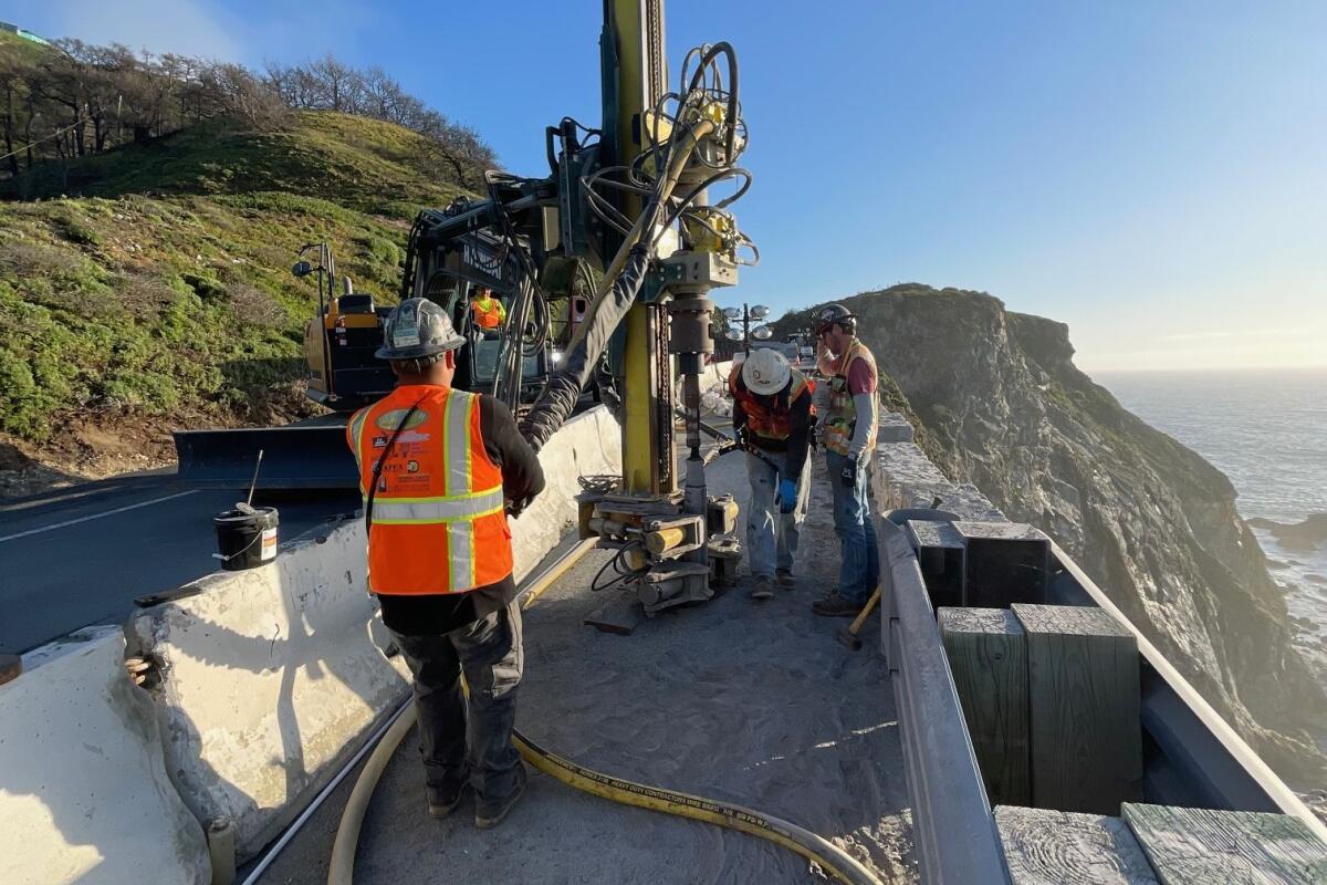
Caltrans’ contractors recently started work on more long-term stabilization there, planning to drill vertical and horizontal supports deep into the cliffside. Crews have also built a concrete wall along the road’s center line to increase one-lane traffic safety
,
and they have
improved drainage in the area, according to the agency.
“The drainage improvements will also help the roadway better withstand extreme weather events, which are becoming more common in the area due to climate change,” CalTrans’ latest update said.
While repairs plug along, Warrick said the USGS will continue to monitor that spot, and many along the coastline.
We see erosion almost on the entire section of Big Sur, Warrick said. Are there areas that are especially stable on Big Sur? Not really.”
The newest USGS images that document changes over the last two months include
data before-and-after photos
from eight different sites, each of
which recorded “substantial movement or potential for it to influence the highway,” Warrick said.
Its not just one site, its a whole handful of sites,” he said.
He said his team will be out flying in a couple weeks to take more images to monitor and track movement, especially after rains have continued since their last images.
Things are still moving out there,” Warrick said. Were going to keep our eyes on that.”