Part of Highway 1 near Big Sur crumbles as new landslide closes more of historic roadway
Fast Break
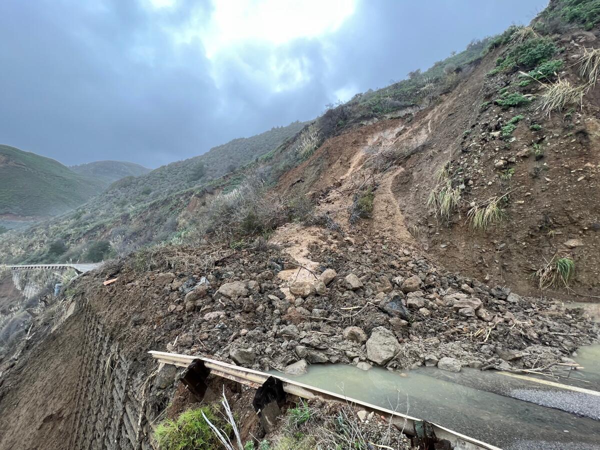
Corinne Purtill March 31, 2024 A roughly 1.4-mile stretch of California’s famed Highway 1 between Big Sur and Carmel-by-the-Sea closed Saturday after a portion of the southbound lane crumbled into the sea. Highway 1 is closed indefinitely from Palo Colorado Road to Rocky Creek Bridge,
the California Department of Transportation said
on social media. Photographs of the closed section posted on the blog of
Big Sur resident Kate Woods Novoa
showed a large chunk missing from the side of the road, as if a hungry creature had taken a bite out of the asphalt. It’s the latest setback for the beloved but volatile highway. The area is still struggling to recover from landslides triggered by last year’s
, which forced the
closure of a 12.1-mile section
along the Big Sur coastline. Just this last week,/for Sunday pub/
Caltrans announced that it had finished its design plan for repairs at Regents Slide, a massive pile of earth and muck blocking the road near milepost 27.8.
The design still needs to make its way through the approval process, which is expected to take about 30 days, Caltrans said in a statement. Once work begins, the agency said, it will take an estimated 100 days to complete the job and reopen the highway.
On Friday night, the closed section was briefly extended an additional 22 miles south to Ragged Point following new slide activity near Alder Creek, Caltrans said on social media. The area was cleared, and the road reopened Saturday morning.
Wet weather forecast for Easter as late-season storm moves through the Southland But landslide activity Saturday afternoon briefly extended the closure an additional 30-plus miles to the north, cutting off outside access to Big Sur entirely. After assessing the damage, Caltrans reopened the road from Rocky Creek Bridge to just north of Dolan Creek Bridge.
Regents Slide is the largest of several landslides in the Big Sur area that occurred as a result of last winters atmospheric rivers. Roughly 300,000 cubic yards of dirt, rock and other debris will be removed from the Regents Slide site during repair work, Caltrans said.
In contrast, landslides at Dani Creek, Gilberts and Mill Creek deposited an average of 30,000 cubic yards of material each.
Crews will start preparing the area for staging machinery
this
week
week of 3/31
, as long as the weather cooperates.
The steepness of the slope and the limited access to the site will make it challenging to mobilize equipment in and out of the project area, the agency said. In the interest of safety and in order to foster efficient productivity, drier conditions at the site will be needed before full repair production can begin.
The closed section of road contains three separate slide sites: Regents Slide, the Dolan Point Slide at milepost 29.5 and Pauls Slide at milepost 22.
Repairs at Dolan Point are expected to be complete by May 1, Caltrans said. Work at Pauls Slide, where a landslide dumped mud and debris over a 2-mile stretch of Highway 1 in January 2023, is expected to finish by late spring.
Recovery has been stymied by ongoing rains and subsequent shifts in the soil. Caltrans was poised to begin cleanup at Pauls Slide last year when a second landslide struck the same area, forcing further delays.
We had a plan, Caltrans District 5 public information officer Jim Shivers told The Times last year, and then things kept moving.